Tuesday, August 13, 2013

No Pain, No Maine

Everyone warned us that southern Maine was worse than the Whites so I don't know why I didn't believe them. I should've heeded their warnings about the jagged, exposed ascents and the knee-grinding, slippery descents. Maybe then I could have prepared, at least mentally, for the terrain that we have been tackling the past two days. But probably not. I think in this instance perhaps ignorance truly was bliss. 

Yesterday we set out early from Gorham, packs laden and oppressive with our bulky resupplies, with one goal in mind: Maine. The first climb up was a gradual 2,000 feet up relatively tame trail that felt substantially more difficult with our full packs, especially considering our slack pack the day before. 

Everything seemed slower for the entire day and, thankfully, my hunger was insatiable so I was able to knock some ounces out of my pack early on. About halfway through our day as we stopped to grab water and down the hill came a petite girl with multiple ear piercings, a mohawk and a day-hiker sized pack. I immediately took her for a section hiker but gave the courtesy of asking if she was hiking the whole trail. She introduced herself as Green Bean and finally I put a face to the name of Cliffnote's prior hiking buddy. Shortly behind her was our buddy Danno who stopped to grab some tea-colored water at the stream with us as well.

We hiked the remainder of the day as a foursome, scrambling hand-over-hand up giant rock slabs and sliding down the other side, gripping desperately to trees and roots to keep from plunging to our deaths and/or breaking our shins. When we finally arrived at Carlo Col Shelter just after the New Hampshire/Maine border I was convinced I couldn't walk another step - and of course the shelter was three tenths of a mile off trail. Damn you, AMC. 

After a blissful night of sleep we awoke early to tackle what promised to be the most challenging day of hiking: crossing over the jumbled mile of boulders that is Mahoosic Notch followed immediately by Mahoosic Arm, a near vertical 1,000+ foot climb up a sheer granite rock face. 

It was more aggressive than we had predicted. The Notch was enormous boulders, appearing to have been dropped from the sky from the arms of god and left without further thought. Between rocks there was no ground only either more boulder or a gaping hole in the absence of one, occasionally with the haunting sound of running water emanating up from the deep crevasses. More often than not climbing over these rocks was not an option so we hugged, straddled, balanced, slid and crawled our way, twice UNDER precarious boulder caverns for the entire mile. If I had any doubt that I would need some semblance of upper body strength for the trail, this squelched that doubt. My arms and shoulders burned by the time we clambered over our last rocks from the exertion of hoisting my body and pack up so many times. 

The Arm may have been worse. The slabs of rock seemed to never end and only become more slick with each step. My calves were on fire by the time we finally reached the summit but the promise of a shelter less than a mile away had me in high spirits. 

The same, perhaps, could not be said for Red Knees. Something has been off with us - perhaps just overexposure - but it seems as though nearly everything I do irks him beyond belief. One day I feel like he is angry that I am going too slow, the next I am forcing him to do too many miles. I am tempted to bring it up but as soon as I do things seem to go back to normal and it seems pointless to bring up. My hopes are high that this will pass and the remainder of our hike - just a few short days - will end on a high note. 

Today I gave some stunningly awful advice. Slow and Steady, an older woman who I met for the first time in the Notch, commented in the shelter that she was running low on Aqua Mira and was concerned that she would need to borrow from other hikers by the end of the trail. While others offered rational suggestions I piped in telling her to just roll the dice with water sources and sprint to Katahdin - giardia takes 3 weeks to show symptoms, right? 

I am becoming apprehensive about the conclusion of this journey. Part of me cannot wait to the point of wanting to drive up to Katahdin just to be finished to return home to get back to the life I have put on hold back in California. Another part of me wants to slow down drastically to both enjoy my time here and because, quite frankly, I am just so damn tired of hiking. By the end of each day my knees are stiff and sore, my ankles and shins aching. But, thanks to our acclimatization to life on the trail, our bodies can nearly heal themselves overnight giving us no viable excuse not to hike on the next day: it's just what we do. 

Either way, I'm making it these remaining 270 miles, if I have to crawl up that final mountain. 


Sunday, August 11, 2013

Redemption

The Appalachian Trail is like an exceptionally manipulative beautiful woman. She knows exactly how to play you, keeping you humbled by the rain, mud and otherwise abusive elements but ensures that you always come back for more with her often stunning beauty and random acts of kindness. After our days in the pouring rain I was through - so prepared to walk out of the Whites and good riddance. And then yesterday happened. 

We had the opportunity to slack pack the 22 miles from Pinkham Notch back to Gorham and, after the days that we had, that sounded like an amazing opportunity to just get it over with (since we had, I'm ashamed to admit, toyed with the idea of just skipping that section all together). We began our hike around 7:30am and things did not get off to a good start; before we even began our ascent up Wildcat Mountain (which I kept wanting to call Thudercat Mountain like that cartoon show with the warrior cat-people...Thundercats, assemble!) Red Knees slipped on a still wet rock, soaking his feet and falling hard on his ass. Following that we began a near vertical 2,000ft ascent up into the Wildcats, often crawling hand over hand up steep, rocky crevasses, but without packs it truly wasn't that bad. 

The day followed suit from there with a series of dramatic ups and downs over rocky terrain but by the time we had reached elevation the sun had broken through and managed to slightly tame the wind and with light loads the walking felt effortless. After a steep descent we arrived at the last hut in the Whites, Carter Notch Hut, which is situated on a beautiful lake, nestled back amongst the pine trees. The hut is the oldest on the AT, built in 1914 but still absolutely beautiful. There we treated ourselves to blueberry coffee cake and applesauce cake with caramel buttercream icing. After a brief chat with the hut master which was cut short by my anxious hiking buddies we pushed on for another near 2,000ft ascent up Carter Dome. 

Again, not that bad and the sun was still shining over clear skies - from Mt. Hight after Carter Dome you could see back to the Presidentials and, indeed, it was perfectly clear all the way to the top of Washington. Despite my jealousy over those with the privilege of summiting that day I was still elated to have the unbroken views of all of the peaks we had struggled over and the gaping Tuckerman's and Harriman's Ravines cutting swathes out of the side of the mountain. 

I should also mention that prior to leaving on our hike we had unofficially bet Bob, the owner of White Birches Campground, that we could be done with this challenging terrain in under 10 hours. Despite being slightly behind schedule this kept us moving forward at a good clip for the entire day. 

When we finally climbed Mount Moriah, the last true mountain in the Whites, I breathed a sigh of relief. All of the nervous energy, the fear and the apprehension flowed out of me in that moment: we had done the Whites. Or maybe they had done us. Either way we had made it through those pages on the map that I had feared for so long in one piece - a bit bruised but otherwise none the worse for wear. The rest of the hike was a 6 mile descent down into Gorham - smooth sailing. 

At the bottom of the hill we stopped briefly at Rattle River Shelter and the 300 mile to go mark on the AT. Under 300 miles - by the end of the day we would be at 298. My head was spinning. No more than a mile after the shelter we are walking along jamming to some music when a packless but gloriously bearded man rounded the bend. I recognized him immediately as Rock Ocean and I just about lost it. We had not seen him since Buena Vista, VA when he reunited us with Headstand and took us all in his wonderful blue Volkswagen camper van to Devil's Backbone Brewery. I dropped what little I was carrying and ran to hug him and immediately grilled him with questions of how the Tribe was doing (they are quickly approaching New Hampshire about 200 miles back). 

After Rock Ocean continued on his hike, Drop Bear - an older Australian man that we had done the slack pack with - asked if I had seen AWOL walk by with a GPS device. AWOL?! As in the author of the thru-hiker bible? Whose account of his hike on the trail was my first true information on what challenges lay ahead of me?! And they didn't interrupt my conversation?? I was still thrilled. What a day. 

We arrived at the parking lot a few minutes later and called up White Birches for a shuttle back to the campsite. While we waited for our ride, who should appear from the woods again but AWOL. I froze with nerves but thankfully Drop Bear, who had met him at trail days, called him over. We spent a few glorious minutes chatting with him, drinking Coca Colas he had in his car (we got trail magic from AWOL?! WHAT?! Best day ever!) before the van arrived. 

Once back at the campground we threw down our things and got ready to head out to go to Walmart for resupply when who should walk in? AWOL. Again. This guy just can't get enough of us! In all fairness he wanted to check out White Birches to update the bible for the coming year but still. I had the opportunity to show him my well loved (aka tattered) AWOL Guide and inform him that the topography line for the climb up to McAfee Knob is incorrectly steep. 

With our ride waiting we had to depart but I was still very much on cloud 9. We resupplied aggressively at Walmart and had a relaxing evening watching Avatar and eating all of the food we realized would be far too heavy to carry. 

Today we walk into Maine. After today there are no more states to check off, only miles to cover and then Katahdin. Lets do this. 


Saturday, August 10, 2013

The Slippery Slope

The Whites are beautiful, please don't get me wrong. For nearly the entire Presidential Range you are in an Alpine Zone, high above tree level with nearly 360 degree views of the surrounding valleys and mountains. It is truly stunning.  That being said, I'm going to rate my experience in the Whites to date at a 6 (granted we still have to slack pack the Wildcats today and from the looks of it the day will be beautiful). 

Above tree line, for all its incredible views, is exceptionally difficult terrain, looking like God picked up armfuls of boulders and dropped them haphazardly in an upside down "U" shape with the top of each pile forming the mountains. There is absolutely no rhyme or reason, with rocks jaggedly sticking up at odd angles, begging you to put your foot down just awkwardly enough to potentially slip and break ankle or two. Not only that but the rocks are all covered with a thin layer of lichen that, when dry, can cause the rocks to be slick and dangerous which is, to a person with a well established fear of heights, a nightmare, especially while climbing hand over hand with nothing behind you but a whole lot of air. Now add water. This terrain in a thunderstorm is like walking out into a tornado and asking the storm to give you all its got (read: scary, slippery and stupid). We had two and a half days of thunderstorms. 

We woke up in our tents relatively early after the night outside of Mitzpah Hut and began the climb up to Mount Washington. The day began in a misty fog, again moistening the rocks just enough to slow our pace, but we made decent time to the Lake of the Clouds Hut, just over Mount Pierce/Clinton, Mount Eisenhower and Mount Monroe, sitting squarely at the base of Washington about 2 miles from the summit. Though the fog had broken several times on our hike up, providing spectacular views of the valley, by the time we arrived at the Hut we were very solidly encased in a opaque cloud wall. After a quick snack break we began the actually fairly easy push to the top of the mountain, passing some fairly ominous warning signs regarding the weather on our way up. 

The weather in the Whites, especially Mount Washington is known for being volatile, with the highest recorded wind speed in the world being recorded atop Mount Washington at 231mph (it might have been even faster but the recording device broke). We learned the reason for this back at Mitzpah: every weather pattern follows a jet stream and, in the United States, nearly all of the jet streams converge in one place - in the Whites - causing unpredictable and violent weather here for the majority of the year. 

We almost missed that we arrived at the top with the fog as dense as it was. Huge buildings arose in front of us that we couldn't see until we were probably 75 feet away and even then they looked foreign - like aliens had landed on the mountain and set up base camp. The whole scene was scarily silent and shrouded in white. Of course, minutes later we walked up to the visitors center and were overwhelmed by the throngs of tourists waddling around enjoying their $3.50/slice pizza and checking the time for when the train would be back to take them down the mountain. And here I was, drenched in sweat, smelling to high heaven when I could have just taken a damn train to see the non-existent view. A bit frustrated, yes, but that I had worked to climb all 6,288ft of that mountain gave me a sense of pride that I knew none of the tourists could feel, nor could they truly appreciate the magnitude of the mountain. Not in the same way, at least. 

After scrambling to write a few letters home we headed out for what looked to be a relatively tame 6 miles to Madison Spring Hut which would put us there solidly between 4:30 and 5:00pm, just in time to get work for stay almost assuredly. The first three miles went by smoothly and we were keeping an excellent pace. But then the rain started and we must've gotten flustered because somewhere in there we took a wrong turn and ended up going around the outside of Mount Jefferson instead of flanking Tuckerman's Ravine as we should have. About a mile in we realized our mistake and desperately tried to figure out the best way back to the AT. It began to rain harder and I became terrified. This is how horror stories about people dying in the Whites begin and here we were. 

We eventually decided that the best way would be to go straight up and over Mount Jefferson (yet another gloriously jumbled pile of rocks). 

I was defeated. Here we were, adding another 4,000 footer to our day (the AT doesn't go over Jefferson - for once it gives you a reprieve and doesn't send you over absolutely every mountain), in the rain, over rocks. I wanted to scream at Red Knees in sheer frustration though I knew that it wasn't his fault so I kept it to myself, save for a few snide remarks that managed to slip by. Every step and every stumble I desperately wanted to give up: to sit down and just call 911 and wait for rescue. 

Though we eventually got back on the trail and made it to the Hut, every step was a struggle. When we saw another pair of northbounders ahead of us by about two tenths of a mile on the trail we knew that they would get the work for stay and that, had we not gotten lost, that would have been us. Thankfully, though they were full, the Hut allowed us to pay $10 each to stay there without the work for stay and we agreed in a heartbeat. 

Overnight the thunderstorms that had been promised the day before materialized in all their splendid glory. From my view by the window I could see long bolts of lightning stretching across the valley as the rain came down in sheets. I was thrilled to be inside. 

In the morning when we awoke it was still raining slightly but we decided to head out. Of course, as we arrive at the ridge line, again, the thunderstorms pick up and the rain fell in sheets, pelting us with what might have been hail but I was too focused on not breaking my ankles to tell for sure. It took us three hours to do the first three miles of our hike, hands down the slowest we have hiked to date. As the rain continued and we walked below the tree line the trail gradually turned from dirt and roots to mud and roots to a solidly flowing river, occasionally interrupted by hidden rocks and roots. The massive amount of runoff from the tops of the mountains also caused all of the rivers to swell violently and pick up pace substantially, going from babbling brook to intense waterfall. The rocks that we were supposed to use to traverse the  rivers were all tragically under water so time and again we had to literally ford the rivers, sacrificing what minute level of dryness (or at least not-squishy-ness) we had in our shoes. I was over it. 

We were supposed to go another 6 miles to the next hut but with an intense (read: dangerous) climb out of Pinkham Notch I threw in the towel and found a hostel near the trail that would come pick us up. We stopped briefly at the post office to grab my mail and then again at the general store to grab some beer. We spent the rest of the day doing laundry and relaxing, watching the rain fall in torrents outside and being glad for the roof over our heads and dry clothing. A few beers in Red Knees and I apologized to each other for being snippy because of the weather and general frustration and all was right again. 

Today we are going to finish up the Whites with a slack pack from Pinkham Notch up over the Wildcat range and back to this hostel in Gorham. The skies are clear with a nice breeze and I am hopeful - let's see how it goes. 


Thursday, August 8, 2013

Whoops

Some days you wake up planning on walking 18 miles and you end up doing 12. Some days, like today, you plan to go 10 miles and end up doing 22 over some of, arguably, the most difficult terrain on the trail in order to have a roof over your head when the pending rain comes in and when you get there you have to tent anyways because the hut master is a prick on a power trip. Or he's just following the rules but whatever I'm peeved. I'll come back to that.

The morning after our zero at Chet's we woke up early only to discover that Red Knees's rain jacket had disappeared in the night. We searched high and low to no avail and ended up in the predicament of having to wait until the outfitter opened at 9:30am before we could get a new jacket before we could hitch before we could get back on the trail. It was a long morning. (Note: breakfast sandwiches from Subway are a terrible idea. My digestive system is still recovering from their pre-cooked egg white fiasco.)

We finally got back to the trail around 10:15am and began the steep climb out of Franconia Notch and up to our frat exposed ridge line. The climb began gradual and became increasingly steep until we hit the ridge going almost hand over hand. Giddy with excitement for the views we were about to see we nearly sprinted through the pine trees and up Little Haystack Mountain until we burst forth from the forest and were treated to one of the best sights I've seen to date: rising in front of us was Mount Lincoln, the trail cut into the exposed ridge with hikers slowly moving up, like the blood pumping through the veins of the mountain. No picture I could ever take would do justice to the magnitude and awesomeness of that view. 

From the top of Mount Lincoln you could see the remaining climbs for the day rising in the distance, looking almost close enough to touch - Mount Lafayette and Mount Garfield. Hikers have a terribly difficult time judging distance and change in altitude above tree line and we were no exception. We used our energy poorly and early leaving us spent by the time Garfield and the ensuing vertical descent were upon us. 

By the time we arrived at Galehead Hut RK and I were spent. Our knees were locked up in pain, our feet throbbed and we were absolutely famished. Before I could even inquire about work for stay I downed three glasses of water and at least two of pink lemonade. Though the hut typically only allows two hikers to do work for stay (and McJetpack was already there) they generously agreed to accommodate both Red Knees and myself. 

We sat patiently while the paying patrons enjoyed their dinner and once they began to dissipate after dessert we sprang into action to aid with the cleanup. When all 3 long picnic tables were cleared off the hut "croo" invited us back for pasta, two kinds of soup, homemade crusty bread, veggies and mocha-caramel cake. We feasted until we couldn't possibly fit in another bite and then went about earning our stay by deep cleaning the storage cabinets and finishing up the last of the dishes. 

Tired and full but unable to put out our sleeping bags in the dining area until after lights out at 9:30pm we lounged in the corner out of sight counting down the minutes. By 9:35pm we were set up and asleep, sprawled across the benches in the dining hall. 

6:30am came far too soon as we hurried to finish packing our things to clear room for the guests to enjoy their breakfasts. We hung around just log enough to snag some delicious leftover multigrain pancakes before heading out on the trail. 

The first climb up to South Twin was aggressively steep for our first climb of the day but we took our time and hammered it out. From there it was all downhill into Zealand Falls Hut where we had the opportunity to work for fresh baked peanut butter-chocolate chip cookies. Damn right I did those dishes. 

Somewhere between Zealand Falls Hut and Crawford Notch we decided to make a serious dent in our climb up to Mount Washington and the 3 miles to Webster Cliffs somehow became 6 miles to Mitzpah Springs Hut. The climbing and descending was steep and terrifying across the board. I wiped out several times, being rescued largely by my pack which took the brunt of the fall on more than one occasion. The late afternoon views of the valley, however, were magnificent, with the dwindling light bouncing off the mountains and lighting our way up the cliffs. 

We arrived at Mitzpah Springs Hut just after 7:00pm after a grueling 21+ miles and waited patiently to inquire about work for stay so that we could have a roof over our heads when the rain comes in tonight. The hut master quickly turned us away saying that they were "full". From the last hut we knew that the huts, especially those at or above tree line in the Presidentials, will almost always bend the rules since there is really no place else safe to camp that is accessible in the remaining hour of daylight. But not this guy. Some combination of power trip and rule follower had him sending us, and me on the verge of exhaustion tears, out to the tent site. Thankfully the tent site attendant took pity on our plight and gave us a platform for free (well, work for stay technically but it got too dark to pick up trash tonight so we will do it first thing in the morning).  

Tired, we set up quickly and ate dinner in silence. Here's hoping it doesn't rain or, if it does, that it gets it all out overnight tonight. 


Monday, August 5, 2013

Zeros for Heros

Everyone warned me that we would have to slow way down in the Whites - that our usual 20 mile days would be cut to 12 or fewer, 15 at most. And as much as I took what I was being told to heart, I really didn't believe them. 12 miles a day? Please. That's a good morning for us usually! The concept of having to slow down so drastically was so far beyond my comprehension that I largely dismissed it. Until yesterday. 

After a cozy night at the Hikers Welcome Hostel we woke up to the smell of bacon, eggs and blueberry pancakes wafting up the stairs. Foggy-eyed we stumbled down the stairs and enjoyed a hearty breakfast, needing the fuel to power us from Kinsman Notch all the way to Franconia Notch. Thankfully we had arranged to slack pack the 16 miles and to stay at Chet's Place that night - a "secret" word-of-mouth advertised hostel in Lincoln, NH. 

With our tiny backpack fully loaded and our packs ready to be dropped at our destination we headed out for Kinsman Notch. The climb in the beginning of the day was steep but manageable and we reached some kind of a ridgeline in good time. Though it looked relatively easy, the rolling, gradually ascending ridge up to Wolf Mountain was jagged and aggressive, sharply ascending and descending, catching us surprisingly off guard. At the top of Wolf Mountain we stopped to enjoy a beer that we had saved from the night before but the dark clouds were moving in towards us quickly so we knew we needed to move. 

Early in the day I began to feel a bit of tightening in my right shin so I shared this with Red Knees, telling him that I may need to slow down to stretch. Immediately his attitude towards me shifted only slightly but perceptibly. With the rain starting to fall there was nothing to be done except continue to hike on and push up Kinsman ridge to the top of the southern peak of Kinsman. 

The view from the top was lackluster as we sat surrounded entirely by cloud but the thickest air was that hanging between Red Knees and myself. Not wanting to bring it up, I desperately tried to be funny and excessively optimistic. I tried to commiserate. I tried being silent. But we continued our hail-pelted, view-less scramble down the vertical rock faces of north Kinsman in tense silence punctuated by occasional conversation or the smack of my trekking poles hitting the ground below as I threw them section by section down the mountain. 

At the bottom of the steep ascent about 13 miles into our day we finally arrived at our first of the AMC Huts - Lonesome Lake. The hut was beautiful with an incredible view of Lonesome Lake just down the hill. We stayed for a few minutes enjoying lemonade and eating the last of our snacks before more ominous clouds pushed us on down the last 3 miles along Cascade Brook Trail - the only section of the Appalachian Trail that I have previously hiked, two years previous with my family on a vacation up to Newfound Lake. There was something so comforting about knowing the trail, knowing where we had gotten lost before, knowing where we had struggled across a river or down a muddy slope. 

At the bottom of the hill we merged with dozens of tourists all out to mill about the bottom of the mountains and check out what sights there were to be seen from the one mile bubble surrounding their cars in the parking lot. In said parking lot we ran into Betterman and Smothers who were awaiting a pick up by OB to head back to Chet's - the same place where we intended to go. What luck. When OB arrived we piled in 6 deep to the tiny car and marinated in our own funk for about half an hour before arriving at the hostel. 

After dropping our things we headed down the street to a garden party being held by one of the neighbors to raise money for the local theatre that was, oh so generously, admitting hikers for free. We feasted on an amazing spread of fresh bread, pasta salad, fried chicken and salad and enjoyed a cocktail while watching live entertainment from the local theatre troupe. Tired and a bit wary of the drunk southbounders that were getting out of hand at the party, Red Knees, SoWay, Cliffnote and myself headed back to the hostel to claim our spaces.

After too much awkward silence had passed I finally lowered myself out of my chair and scooted over to Red Knees to try and hash out what was going on. To be honest I'm not even sure what he or I said but what it really boiled down to was fear of being out here alone. With a group you have a cushion - one person can fall back, another can get off trail and you still have some semblance of "group". We just have each other and for him to hear me talk about pain in my shin - an injury which previously took me off trail for a week - must have been petrifying. Hurt by what felt like rejection from my best friend (but which had dissipated by morning) I crawled back into my chair and tried to drift to sleep. 

Somewhere between sleep and awake the lights flicked back on and an officer walked through the basement with Chet to the back porch, looking for one of the Southbounders who had - after we had left the garden party - punched another hiker so violently in his drunken stupor that he was knocked unconscious. I don't know exactly what happened but I do know that there was screaming and I am shocked that any of us were allowed to remain at all. 

After a fitful night of sleep I awoke and moved from the chair/floor to a mattress that had been abandoned by and early riser and continued to rest. An hour later Red Knees lumbered over and we got up to begin a load of laundry and resupply. 

Once we were fully resupplied and ready to go we decided that a zero would be in our best interests - to let our knees and shins heal from our decidedly foolishly fast descent of Kinsman Mountain the day before. We spent the day walking through town, purchasing necessities at the outfitter, napping, writing post cards and attempting to compile a list of all of the trail angels that have aided us along the way (it took hours and so far the list is 50 people long - yikes!). Tomorrow we head back to Franconia Notch to tackle this next ridgeline. I am nervous for our first day in the Whites with a full back but thrilled for the views it promises to bring. 

Saturday, August 3, 2013

Hostel Hopping

We have been out on this trail for nearly five months now. That's five months of sleeping in shelters, under the stars, in tents during violent thunderstorms and while various vermin roam around menacingly in the dark. By this point we have earned our stripes and, perhaps, have earned some rest indoors, safe from the mosquitos, rain and bears. Well, maybe we have earned some of it.

Enter hostels - sometimes free, often not, but always a welcome retreat from the solidarity and unknown of the wilderness.

After leaving Tigger's Tree House and our very warm not-so-mobile home we returned to the trail refreshed and rejuvenated, ready for the 18 miles we had planned for the day. Per usual, we divided the day up into sections: 5 miles of hiking, 45 minutes of laying our tents out to dry, 6 miles of hiking, lunch, etc. The beginning of the day went according to plan - Red Knees and I powered up the first climb and arrived at Moose Mountain Shelter in record time. The shelter was fairly new and the breeze coming through was promising so we strung up our tents to dry out from the dew-soaking they had received two nights previous. At one point the wind picked up so substantially that Red Knees' tent lifted off the ground and floated along, dangerously close to becoming a kite billowing off the top of the mountain.

Hearts still a flutter from the near departure of housing we began our descent down the mountain. We had heard from Cosmonaut at Tiggers that the shelter at the top of Smarts Mountain was questionable but that it would be cool to sleep up in the fire tower at the top. Eager for a good sunrise and sunset we set off over the next few bumps to Smarts. When we reached the road crossing at the foot of the mountain we began to actively search for a place to enjoy our lunches. Like a gift from up above a sign came into view, inviting us to a house just off the trail belonging to Bill Ackerly - the Ice Cream Man.

His house is quite literally ON the trail and he readily welcomed us to his home, placing an ice cream bar and the log book in our hands before you could figure out who else was there or what music was wafting from the record player. Bill, we learned, is a retired Harvard professor and, at 85 years old, has one of the most visited homes on the trail (let's be realistic - what thru-hiker is going to see a sign advertising free ice cream and sodas and not stop in for a break, especially when searching for a place to have lunch?). I love this man.

We settled in and began to speak with the other hikers at the house, mostly Southbounders (Blue Skies, Yogi and I forgot everyone else's name but, let's be realistic, we are never going to see these hikers again - have fun in the crappy sections!) and began to get cozy - the kiss of death for motivation. As if on cue, in rolled the dark clouds, promising rain and Bill changed up the music to smooth 40s music. My eyelids instantly sagged and I looked at Red Knees with the inquisitive "are you thinking what I'm thinking?" eyes. He was. We were staying.

That night we (well, I) cooked up a taco feast to feed the 10 of us that decided to stay the night. At one point I made a comment about how we should have gotten Coronas instead of PBR and Bill instantly brings out a handle of tequila. Sneaky son of a gun. RK and I steered clear of the tequila, knowing that we were going to have to put in the miles the following day to make up for our almost nero. After relaxing for a while we went and set up on the front porch and drifted off to sleep.

Around 4am I was brutally awakened by the insanity-inducing mosquito buzz in my ears and the feeling of dozens of the tiny demons landing all over my exposed skin. It was pouring rain and every single insect was seeking sanctuary, apparently, on my face. I cinched myself into my sleeping bag liner, in my sleeping bag, and covered my face with my fleece and I could still hear them and feel them attempting to dive bomb me through my multiple layers. Aw hell no. Perhaps inappropriately I hopped inside, still in my sleeping bag, and lay down on the couch and immediately fell asleep.

A few hours later as everyone was stirring I began to pack up my things. Back on the porch I could not for the life of me find my food bag where I had left it. And then I saw it: dangling off the edge of the porch, torn to shreds, surrounded by bagel and poptart crumbs. My heart dropped: raccoon attack. How much food did I lose? Is the bag still usable? Was that mangey almost assuredly rabid scoundrel anywhere near me in my bag and if a rabid animal eats some of your food is the rest of it safe to eat?

Yet again, Bill to the rescue. Into the general store we went and picked up a few more supplies (which he generously would not let me pay for) to get me to the next town. With a plastic bag liner on the inside my existing food bag actually worked alright so we packed up quickly and got on the trail. The climb up Smarts Mountain was tough but doable and thank goodness we didn't stay at the top - the fire tower was drafty, rickety and terrifying and the cabin was gross. We briefly rested in the fire tower before my fear of heights got the better of me and we had to move on.

Somewhere in the next 10 miles I realized, as I pulled out my pack cover as the rain began to sprinkle down, that I didn't have my purse (well, a Sea-to-Summit bag that I have been using to hold my ID and credit card, if that counts). Either way, fuck. I knew it had to be at Bill's house so I forced Red Knees to death sprint to the next summit where I called 411 and was, thankfully, able to get the phone number. I left a message and crossed my fingers. On the way down Mount Cube my phone buzzed letting me know that there was a voicemail and thank goodness my purse was at his house safe and sound.

We finished our 16 mile day early (around 3pm) and got a hitch up the road to the Mount Cube Sugar Farm - a small maple syrup farm that allows hikers to stay for free. No one was there so we dropped our packs, left a note, and went about hitching all the way back to where we had left from that morning. We were able to hitch quickly there and back (only two hitches!) including a trip to the general store for some Chef Boyardi raviolis (I had a day - it was necessary).

Back at the farm we met Peter, the owner of the farm, who was hard at work boiling maple syrup. The farm, he told us, used to be right on the Appalachian Trail before it was rerouted over Mount Cube. Back in the 1950s, in fact, Grandma Gatewood (the first woman to thru-hike the Appalachian Trail at the age of 67) had stayed at the farm on both of her thru-hikes. Grandma Gatewood is a badass. When she hiked in 1955 and 1957 the term "lightweight" was so far from what we currently have that it will blow your mind. She literally hiked with a burlap sack with all of her belongings slung over one shoulder and a single trekking stick. When it rained, she draped herself with a shower curtain that doubled as her tarp tent. I will never complain again.

This morning started rainy but we were inside on cots and my food bag was un-attacked so it was, by all accounts, a successful morning. Once the rain stopped, Red Knees and I hit the trail. The first 10 miles blew by and we arrived at the base of Mount Moosilauke by 11:00am. At the hostel down the way we ran into a section hiker who offered to drive us up to Kinsman Notch so we downed Mountain Dew, threw a few essentials into a day pack and drove off (of course, without rain gear or food - no, we did not have lunch. Rookie mistake).

We were so jacked up on Mountain Dew that we basically ran up the nearly vertical south side of Moosilauke - we made it to the summit 5 miles up in under 2 hours. Unheard of. It felt amazing to have my body work so effortlessly up such difficult terrain, especially as we watched jacked up football stars huff and puff down the mountain, complaining about their all-night bender that was causing them to sweat out what I can only surmise was some combination of vodka and redbull. Pretty cool, bro.

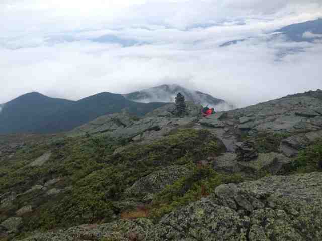
The view at the top was incredible, though the wind was brutal and threatened to chill us to the bone if we lingered too long. The menacing dark clouds on the horizon hastened our decision as well so we began our descent down back to the road. It was steep but bearable, and we passed several of our friends on the way down. At the bottom, after smacking my legs on some 50 pound boulders, we forded a stream before heading back to the Hiker Welcome Hostel.

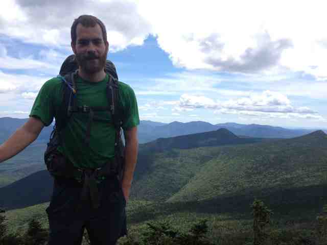
Showered, fed and with a cold beer in hand, I am happy and warm (and, for the first time in months, writing this entry on a computer so please pardon my rambling). I am excited and terrified that we are officially in the White Mountains, nervous for the occasional twinges that I feel in my right shin, sad but ready for this insane adventure to come to an end. It is almost impossible to think that 27 days from now, if all goes according to plan, I will be drinking champagne with my dad on the top of Mount Katahdin - my Mecca. But for now we will continue to take it one mile at a time, working for every one of the next 389 miles.


Thursday, August 1, 2013

The 13th State

I guess perhaps I thought it wouldn't ever happen - not really. New Hampshire was such a pipe dream - we would look ahead in the book at the mountains in the Whites and especially the Presidentials with awe and terror, deciding that no, we don't have to think about those quite yet. But suddenly we are in southern New Hampshire, two days away from Glencliff and the base of Mount Moosilauke, our first mountain over 4,000ft since Virginia and our longest climb to date. Holy crap.

After our majestic stay at the lookout we planned for two days into Hanover, NH. We awoke in the cabin the next morning bright eyed and bushy tailed, so grateful to have gotten a night out of the buggy open air. The first 6 miles of the day flew by as I desperately chased Red Knees down the mountain to the road below the Lookout. Unfortunately for both of us I didn't realize that he had waited for me at the shelter 2.6 miles into the day and that by hurrying to "keep up" with him I had made him quite literally run the trail to catch back up. Whoops, sorry buddy. The sight of him running down the side of a Vermont country road, backpack bouncing all over the place was one to remember. 

After that initial descent we went into a sort of mini roller coaster, steeply ascending and descending over relatively small mountains but the quick changes from super steep up to super steep down were challenging to say the least. Thankfully we had a prize at the end - the possibility of trail magic and a definite stop at Cloudland Market. And oh did we get both!

At the bottom of the last descent into Cloudland there was a bag with cold Gatorades (gift from the gods!) and a cooler graffitied with the names of other hikers filled with peanut butter and jelly sandwiches (with strawberry, not grape, jam hallelujah!), cheeze-its, carrots, grapes and breath mints. We sat down mid trail with Sir Pantsalot and Daddy Longlegs who had arrived before us and feasted for a late lunch.

Thank goodness we did because for all it's beauty, Cloudland Market wasn't much of a market. Inside they had one whole refrigerator full of beef (apparently they slaughter some of their cows for some killer grass fed beef. It looked good but lord knows I wasn't about to pack out a raw rib-eye steak), and another with a few types of Vermont cheese, pints of ice cream and locally made cream soda. If I has been in the mood for dairy or liked cream soda we would've been in business. Nevertheless we all posted up on their beautiful wrap around porch and laid in the sun and charged up our electronics. I'll take it. 

We were back on the road by just after 3pm for what ended up being a really not that downhill death-sprint descent into West Hartford, VT. Of course I ran out of water with 3.5 miles to go and decided: oh screw it, lets just go. Needless to say when we got to the general store just over an hour later I promptly purchased a quart of Powerade and consumed it in under 5 minutes. Note: NEVER drink Powerade that fast. You will feel like you're about to die. 

I recovered quickly from my faux pas and Red Knees and I ordered sandwiches and picked up a few snacks for the road. We walked just a few houses down before turning into a house with an AT sign advertising water and camping. Turns out this was the house of a previous thru-hiker, Steve (his trail name had something to do with the fact that he has a mustache but it is evading me), who allows hikers to camp on his lawn, full up on water, charge electronics and bath in the snow runoff stream behind his house (not really but oooh baby was that some chilly water!). It was a dream. 

The next morning we awoke early to find all of our things soaked through with dew. We packed up our soggy belongings and hit the road by 7am to make a big push for New Hampshire, 10 miles away. After an easy 3 hours we popped out onto the road for some road walking which led us across the Connecticut River and into the town of Hanover, NH a chic Ivy League college town that caters remarkably well to hikers with most businesses offering some hiker special (free bagel, free pizza, cheap sandwich...). We dropped our packs at the Dartmouth Outdoor Center and headed for the post office. 

When I got there I was expecting to pick up one package from my brother. I was totally unprepared for the cards and care packages that I actually receives. I think at one point I was actually on the verge of tears I felt so much love and support from my friends at home. People are amazing sometimes. 

After a delicious lunch at a restaurant across the way from the post office I stopped by Barnes and Noble and picked up some cards so I could write letters home to thank everyone for their words of encouragement. l went a bit overboard and ended up writing a few novels but at least they were finished.

We left town around 4:30pm, not wanting to stay in the excessively expensive college town that was teaming with 18 year olds prepping for Freshman orientation. Instead we pushed on 6 more miles to Etna, NH where we were picked up to stay at Tiggers Tree House Hostel.

What a gem of a place! Red Knees and I were given our very own mobile home parked outside their house (that's one way to keep the hiker stink out!) and we're given access to the laundry, shower and a plethora of food and beverages they had in a fridge just for hikers. Plus we were able to crash in front of the TV to watch Ironman 2 and X-Men 2 while eating the Subway sandwiches that we had carried with us from Hanover and finish the letters that we (well, I) had started.

We were up late but accomplished so much that it was worth it. Today will be a big day with some decent climbs ahead of us but we have the prospect of sleeping in a fire tower atop a mountain tonight which I would never turn down. 

White Mountains, we're coming for ya!